 However, it is probable that an even earlier Saxon church was erected here,
possibly in the 10th or 11th century although it may not necessarily have been
dedicated to St Nicholas at that time.
However, it is probable that an even earlier Saxon church was erected here,
possibly in the 10th or 11th century although it may not necessarily have been
dedicated to St Nicholas at that time.(Part 1, Chapter 2, Section 5) ( Bk. Index )
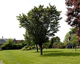
In tranquil gardens behind Angmering's Library once stood the old parish church of East Angmering, dedicated to St Nicholas. Barely 130 metres to west was the parish church of West Angmering - this still stands today and is known as St Margaret's. Following the Reformation, the two benefices (plus that of Bargham in the north of Angmering) were amalgamated (circa 1573) into the single parish that we know today.
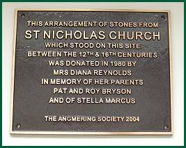
The only indication that St Nicholas' Church stood here is a
representative pile of flint stones plus a small part of a column and its
plinth. A cast bronze plaque (see below right) placed on these stones by
The Angmering Society records that a church stood on this site for 400 years
between the 12th and 16th centuries.
However, it is probable that an even earlier Saxon church was erected here,
possibly in the 10th or 11th century although it may not necessarily have been
dedicated to St Nicholas at that time.
After the demolition of St. Nicholas' Church in the late 16th century,
the land was put into use as garden or allotments. The tithe map of 1839
describes it as 'garden' owned by the Rector of St. Margaret's. Some early
Ordnance Maps mark the site (erroneously) as the ruins of 'St. Peter's Church'.
For many years the ground was used as gardens and a recreational area
for the children attending Older's Charity School. Following the closure of the
School in 1966 and its subsequent conversion into the present village library,
the land was sold to a local builder who applied for planning permission for
housing development. This was refused and in 1978 the site was purchased by
Arun District Council and leased to Angmering Parish Council as a recreational
area for the village. On May 8th 1980 it was officially opened by Her Grace
Lavinia, Duchess of Norfolk as St. Nicholas' Garden.
From surviving Wills, it can be determined that few (if any) burials took place after 1560 - no registers survive. Indeed, it is unlikely that any registers were ever established. Those of St Margaret's itself did not commence until 1562. The known rectors of St Nicholas' Church are as follows:
| 1263 | Engeraud de Brok | bef | 1432 | Edward Stoppe | |||
| bef | 1302 | Peter de Dene (intruded) | 1434 | Thomas Hardy | |||
| 1302 | Ralph de Allegate | 1478 | David Barnard | ||||
| 1371 | Adam | bef | 1516 | John Prideaux (Prediaux) | |||
| 1380 | John Watersfeld | 1516 | Thomas Combes | ||||
| 1384 | John Russell | 1528 | Edward Hygons | ||||
| 1385 | Richard Cloupp | 1528 | Christopher Ellis (Elys) | ||||
| 1386 | John Boure | 1548 | William Foster | ||||
| 1397 | John Shelford | bef | 1561 | St. John Henhays (? curate) | |||
| bef | 1404 | John Bowrer | 1579 | Walter Chatfylde | |||
| 1404 | John Martyn | 1581 | Richard Humfrey |
In 1974, a unit from the Sussex Archaeological Society led by Dr Owen Bedwin excavated the site and his findings are recorded in an article written by him in SAC Vol. 113 (1975). A broad summary of the findings are detailed below.
Very little remained of any walls above the foundations, the material from these walls no doubt having been robbed and used in the construction of other properties in the village. Not a single piece of mortared masonry with flints was found in the demolition debris. Dr Bedwin suggests that this may be indicative of the building being systematically demolished quickly rather than slow haphazard decay. Glazed floor tiles were found mortared in position in a few places. Dr Bedwin's article in SAC Vol. 13 runs to 18 pages and it is recommended that readers who are interested in greater detail of the excavation look at the complete article, a copy of which may be found in Angmering Library in the Local Studies folders. The SAC article also contains 10 photographic plates and detailed diagrams of the foundations.
It is believed the church developed in four different stages. The reconstructed ground plans of these are shown below:
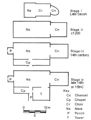 |
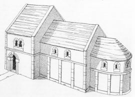
This stage of the development is characterised by the apsidal shape of the chancel which was typical of Saxon churches. The quality of the mortar at this phase was the best and most tenacious found on the whole site. The foundations were of unmortared flint and in one location several Roman tiles were found which might have come from the Romano-British villa one mile to the west. There was some slight evidence that there may have been an even earlier Saxon church on the site. A reconstruction of the church can be seen below.
In this phase, the nave was lenghtened and broadened. Most of the Saxon walls were demolished and the new walls erected in the chancel were generally more feeble than the Saxon ones, the foundations being quite shallow. The mortar used was powdery and friable. Three pottery sherds in the foundations help date this structure.
It was the mortar which helped identify the development of this phase together with a piece of 14thC pottery discovered near the founadtions. The mortar was different in colour to the earlier phases, contained beach sand and the quality was better than Phase 2. A chapel was added on substantial foundations as was a new well-built eastern end wall to the chancel. A porch was also added at this time at the western end.
A tower was built on the south side of the church which meant demolishing part of the chapel. A second porch was added on the west side of this tower. The tower was built on massive foundations and the quality of the mortar was quite strong. Again, a small pottery sherd from the 14th Century in the foundations helps date the tower and, by the mortar type, the porch also. Some 45 glazed floor tiles, or parts of tiles, were found mortared into place between the doorway of the tower and the nave. A reconstruction of the church can be seen below.
 |
 |
|
| A reconstruction of the earliest Saxon Church | A
reconstruction of the final church 14th or 15thC (as envisaged by Dr Owen Bedwin's 1974 excavation) |
Among the features discovered during the excavations were two
elaborately built tombs within the Church. Both were constructed of carefully
shaped chalk blocks and were lined with plaster. One was an altar tomb
containing the skeleton of a man estimated to be about forty years old, with
the remains of a pewter chalice, presumably buried with the corpse. Burial
beneath the altar was an honour usually reserved for members of the Clergy but
there was no supporting documentary evidence found to identify this particular
person.
The other significant burial was a double tomb found beneath
the floor of the nave containing two female skeletons separated by a thin
vertical partition of chalk blocks. Again there was no supporting evidence for
identification.
There were several other less sophisticated interments within the church and many outside. Outside the church, a grave was found almost wherever a trowel was put into the ground. The main graveyard was located rather unusually on on the north side of the Church but this area was not excavated. Its position was due to the fact that on the south side of the church, the ground rapidly fell away down a bank where the houses in Church Road are located today.
Fragments of painted wall plaster suggested that the interior of the Church was decorated with murals similar to those to be seen at Hardham and other early Churches in Sussex. Glazed floor tiles and pieces of dull red painted glass (2 - 4 mm thick) were also found, indicating an unusually high level of decoration for this Church.
Amongst the small items discovered in the debris was a circular object made of lead, four centimetres in diameter which was identified as a Papal Bull belonging to the time of Pope Boniface IX (1389-1404). This find suggested some direct communication between the Pope and Angmering. A small pendant or brooch was found of gilt on silver in the demolition debris inside the chancel - its date could not be established. Additionally, some coins were found. The first was a brass jetton from Nurenburg of the late 16thC and the second was a worn silver penny from the reign of Richard I (1189-1199). The last was a William III copper halfpenny dated 1699, clearly lost on the site at a later date.
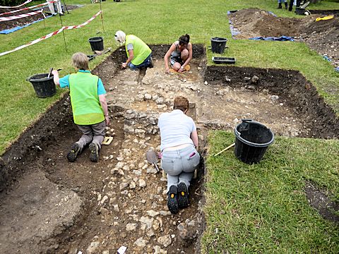
In 2015, a team from Worthing Archaeological Society (WAS), and local volunteers, carried out excavations on the site over a two week period commencing 6th June. They had previously carried out a geophysical survey in 2013 to determine broadly the locations of the church walls or other features. This allowed them to identify sites of potential interest where discrete trenches could be dug. The excavations were commissioned by Angmering Parish Council.
It should be noted that this specific article on the 2015 excavations is not an official report and is based entirely upon observations and discussions of the author with the WAS team leaders who were exceptionally helpful to visitors to the site including children from both Primary schools who participated in the dig during its second week. The WAS team suggested that, together with the excavations of the 1974 and 2015 digs, some 90% of the church's walls had been unearthed over the two digs. No doubt a report will be issued later to Angmering Parish Council when the results of the excavations have been analysed at which time it will hopefully be possible for a summary to be published on this page.
It was not the intention to seek burial places; however, in the course of tracing walls, some became evident. The tops of two adjoining plaster lined tombs were found in the centre of the nave but the archaeologists made no attempt to probe deeper. Close by, in two locations in two different trenches, some fragments of bone were discovered.
A trench was cut over the south-east corner of what Dr Bedwin concluded was the tower from his 1974 excavation. Certainly, there were substantial flint foundations of the corner of a building to be seen (see photo below). However, what puzzled the archeologists was that would the Normans have built the tower of a church just 3 metres from a significant 4.5 metres drop of the ancient river bank when there would have been a safer and more conventional place to build it at the west end of the church, as in the case of St Margaret's Church just 100 metres away? At the end of the excavation, a previously unknown photo of the west end of the 1974 excavations was found which showed substantial square foundations which may have been the site of the tower and not a porch as Dr Bedwin had concluded. Could Dr Bedwin's "tower" have actually been a side chapel? The conclusions in the final report are awaited with interest.
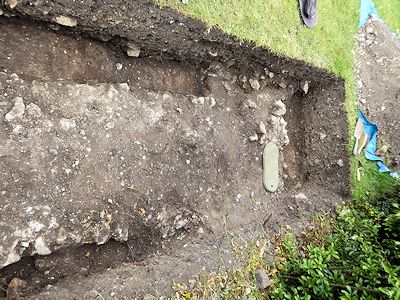
This was probably the most interesting of the trenches excavated with much going on and needing some analysis (see photo below). However, there were clearly substantial Norman foundations over the top of what appeared to be the original late-Saxon foundations. An extension of the trench appeared to confirm the apsidal shape of the Saxon chancel wall. The more substantial SE foundations of the Norman chancel wall could clearly be seen.
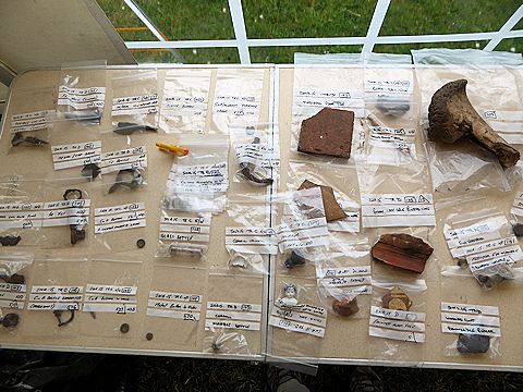
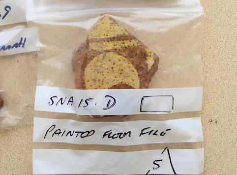
There were numerous small finds - some medieval but others 18th to 20th century - perhaps reflecting the fact St Nicholas Gardens were used by William Older's Charity School as a recreation area in earlier times. This may account for numerous buttons found. However, medieval pottery and floor tiles, coins, the head and shoulders of a small 18thC china doll, a Bronze Age piece of worked flint, and metal artifacts were also found. Additionally, a piece of Horsham slab was found. This is interesting as it could suggest that the Norman church was roofed in that material, it being a useful stone for building when the site was robbed of materials in the 16thC. Painted floor tiles would also have been prized, but an excellent small fragment was found during the dig (see photo below - right).
The geophysical survey in 2013 had identified what appeared to be foundations north of the church's north wall. However, the trenches found that these were the drainage system and concrete covering of a cesspit to the William Olders's Charity School's toilet block built in the late-19thC or early-20thC.
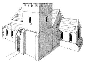
The excavations by Dr Owen Bedwin in 1974 suggested that the tower was built on the south side of the church. However, the WAS 2015 excavation felt that the width of the walls on that south side position and its close proximity to the river bank would have made this most unlikely. The foundations would have been insufficient to support a tower. However, the foundations of the structure previously suggested by Dr Bedwin to be a porch on the west side of the church were far more substantial and capable of supporting a tower. Further, if this were the case, the position of the tower would be more in keeping with other Sussex churches of the period. WAS therefore projected that, in its last stage, the building would likely to have had this appearance:
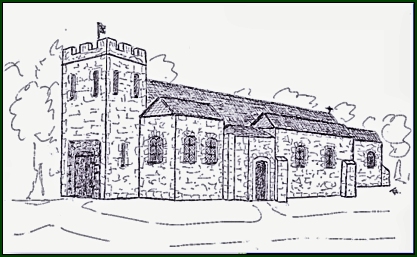
Illustration by Bob Turner of WAS, 2015
Neil Rogers-Davis
22 June 2015 (updated 10 Oct 2019)
Source Information:
N A Rogers-Davis
Last updated 10 October 2019