|
Angmering - all at Sea! by RW Standing |
What has Angmering got to do with the sea, other than a brisk walk through East Preston to Angmering-on-Sea with its beach and greensward - the name of that estate lifted, without leave, from Angmering simply because of the station that served the area in 1913. In fact, unlikely though it seems, the village area has been connected with the sea for most of its history, whether we go back half a million years, or only to the foundation of the settlement in Roman and Saxon times.
Few people have not heard of Boxgrove Man, or two men, a few fragments of whom was discovered there in 1994 and 1995. A bulky individual related to modern man who lived between 200,000 and 400,000 years ago. He might just as well have been found locally, since the raised beach at Boxgrove extends along the Sussex coastal plain, through the north of Angmering village, and under Highdown to the east. Indeed, at various periods, Highdown formed something akin to Beachy Head, towering over the shore of an encroaching sea, eating into the ancient chalk downs that had connected through to France before the English Channel was formed. To the west of the Arun there are a series of such beaches, of different dates, and they presumably only run together at Angmering because of Highdown, that southerly outcrop of the South Downs.
Since the last Ice Age was at its height some 13,000 years ago, our world has been warming, so that what is now Sussex has become inhabitable. A rising sea, and falling land levels, have wrought great change. By the time of the Roman occupation, in the first four centuries AD, the English Channel had long been formed, but at Selsey the coastline may have been two kilometres south of the present shoreline. Further east towards Beachy Head erosion has been less until recent years, while beyond that the reverse applies, with Pevensey Fort now far inland.
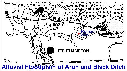
No mere chance chose the site of Angmering Roman Villa. At that time, and more so later in Medieval times, the coast of Sussex was indented by inlets and tidal estuaries, and did not have the present smooth artificial line of beach, protecting firm land. The villa stood at the edge of a fertile brickearth plain, providing prime farmland, with easy navigation to its door on the west side by a branch of the Trisantona or Arun estuary (see Map below).
| |
Longshore drift tended to throw mouths of rivers to the east, away from the run of tides and prevailing wind. Much of the coast may have been protected at times by these shingle bars, with saltmarsh forming behind together with a gradual silting of the estuaries. This is what the Saxon invaders and settlers found when they conquered the British, after protection by Rome ceased in AD 410.
It is notable that East Preston and Lyminster were the only manors in the Arun valley which had saltpans in Domesday. Quite possibly those listed under Lyminster were in fact at Kingston which was still part of that great estate. Now saltpans were not found in open sea beaches, but in estuaries and compartments separate from the sea. The Arun therefore did not issue straight into the Channel but into saltmarsh compartments protected by shingle spits.
This is supported by the story, embroidered by time, recounted in, The High Stream of Arundel, published in 1636 [Fowler 1929] . "And here let me remember an Old Tradition [by men of repute] that the High Stream in Arundell Levell did Issue in former times into the Sea at Penhouse in Lancing". Or rather that compartments linked through to the Adur, with the rivers having delta mouths. The river Arun seems in Roman times to have formed a wide tidal estuary ...... In the early Middle Ages there may have been more than one channels, as in the river Adur at Bramber...[VCH Vol V pt 1 Arundel].
In the 16th century the river still had its floodplain and only gradually was this reclaimed in and around Arundel. At Angmering itself when John Palmer acquired ownership of the manor, complaints were made about his enclosing villagers lands. "Complainants say that warning has been given to all the tenants in one street of the Lordship, "beyeng nyegh unto the seae syde," ...... "which thing is weaknynge to your Grace's costes [coasts] of the seae ther." [Skeet p27] Clearly the estuary was still seen as a branch of the sea flooding at high tide.
At Rustington as late as 1568 considerable saltmarsh pasture survived as common pasture for the tenants. There is also ... one Salte marshe lyenge betwene the stonebeache and the fyrme lande conteyning by estymacion CC [200] acres being the comen for the tenants of bothe mannors ... for every acre of lande ... in the comen felde the goinge of one shepe". [Cowdray Archives MD306]
By the time of the Armada Map made in 1587 by Sir Thomas Palmer and Walter Covert, much of the postulated coastal barriers had been eroded, but there was still an indented coastline with sandy commons and saltmarsh. . South of Angmering the villages of Ferring, Kingston and East Preston were now more open to the sea. A landing stade for boats at Kingston was a relict of some more safe harbourage that once existed, and by 1640 the parish had lost its chapel, by which time most of the South Common at East Preston was also gone.
At Arundel, during the Middle Ages through to the 16th century and after, considerable estuarine land was inned. The river was gradually embanked until at last it was canalised. At Wick a large area quite separate from the old manor and village lands, called Old Marsh, had presumably been inned during the 16th century. Any link Angmering had once had with the sea was now reduced to the Black Ditch stream.
Nevertheless, if some anecdotes about coastal erosion were true, Angmering might by now have become a coastal village once again. For instance, there is no local evidence for the Great Storm of 1703 devouring the village of Kingston. The coastline in the mid 18th century is known, and in a 1671 survey it can be estimated as between one and two chains further south - with 20 metres equalling one chain - and that does not equate to disaster. Arguably some five chains of land have been lost locally since Kingston Chapel fell under the waves in 1640.
However, that Angmering had become removed from direct access to the sea did not prevent the occasional cottager being a fisherman. In the 19th century John Cheeseman managed to pursue the trade all his life. Others were mariners at Littlehampton, and further afield, some going down with their ships.
More interestingly all local villages had some connection with smuggling, not least Angmering. As Skeet recounted, "There were many men still living in 1866 who had been engaged in smuggling, some of them highly respectable, who thought there was nothing wrong in it. It was winked at and encouraged by the farmers and small landed gentry." [F Skeet History of Angmering, 1921] The farmers and gentry well knew that occasional "work of night" supplemented what had been subsistence wages.
General Ref: The Archaeology of Sussex to AD 2000 editor David Rudling 2003
RW Standing 2004
Last updated 1 February 2004